For beginning F5J pilots there is often initial confusion regarding the F5J Start Height parameter. Let's take a look at the FAI F5J regulations and then we'll walk through several examples to illustrate several key points.
From the FAI F5J regulations, section 5.5.11.1.3 h) (bold emphasis added):
The essential functions of the AMRT (altimeter/motor run timer) are:
i) To record and display the maximum height attained (Start Height), above a ground level reference between the instant of motor start and 10 seconds after the motor is stopped and
ii) To restrict the operation of the motor by the competitor to a single continuous run not exceeding 30 seconds.
For convenience let's define the "launch phase" as the time between motor start and 10 seconds after the motor cuts off, for whatever reason. The F5J Start Height is simply the peak height attained during the launch phase. A common misconception is that the Start Height is measured 10 seconds after the motor is cutoff. It's not!
From a scoring perspective here's an extract from FAI F5J regulations 5.5.11.12 e):
Each meter of the recorded Start Height results in a deduction of half (0.5) a point up to 200m and three (3) points above it.
In other words the more your Start Height exceeds 200 meters the more you will be hit with that costly 3 point per meter penalty. Example: Say that during the launch phase your plane hit a maximum of 215 meters. Your Start Height penalty would therefore be (200 * 0.5) + (15*3) = 145 points. On the other hand if your plane only hit 180 meters during the launch phase then your Start Height penalty would be (180*0.5) = 90 points.
You might wonder if you could legally use telemetry to send back the current altitude of your plane and keep you from crossing that 200 meter line. Answer: Nice try, but no! (FAI 5.5.11.1.3 d) Any device for the transmission of information from the model aircraft to the competitor is prohibited.)
Let's look at several F5J launch examples:
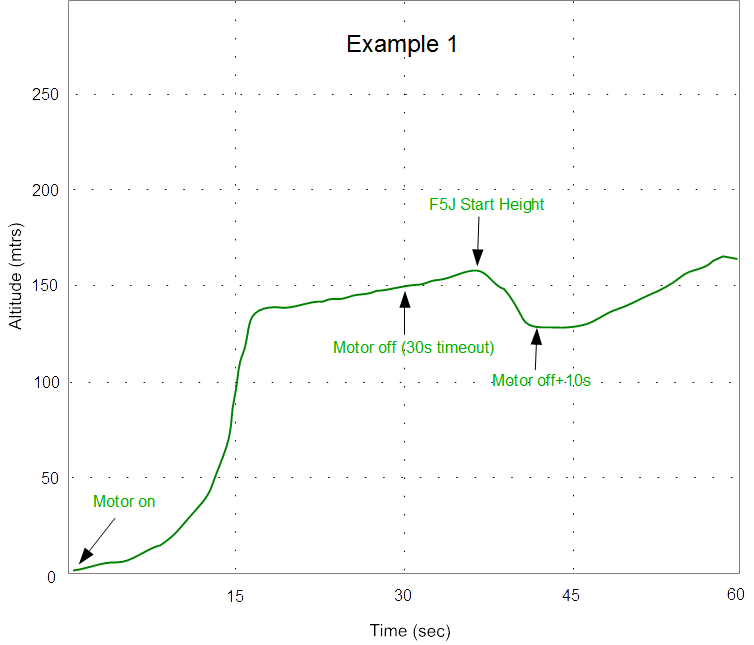
Example 1 shows the plane climbing fairly steeply for ~17 seconds and then climbing less aggressively until the motor cuts off automatically at the 30 second maximum time. From there the "zoom" climb continues for about 6 seconds and then the pilot dives his plane 30 meters before the "motor-off + 10 seconds" mark has expired. The F5J Start Height is recorded at 160 meters, which is the highest point between motor-on and motor-off + 10 seconds (i.e. The dive after the zoom did absolutely nothing to reduce the Start Height penalty).
Example 2 shows the plane executing a steady, steep climb up to 220 meters and then dive until the pilot cuts off the motor at 200 meters and ~26 seconds. The plane continues to dive until it reaches an altitude of ~160 meters when the pilot starts a zoom climb. Note that in this example the F5J Start Height of 220 meters occurred before the motor cutoff (i.e. it is the peak altitude between motor-on and motor-off + 10 seconds.
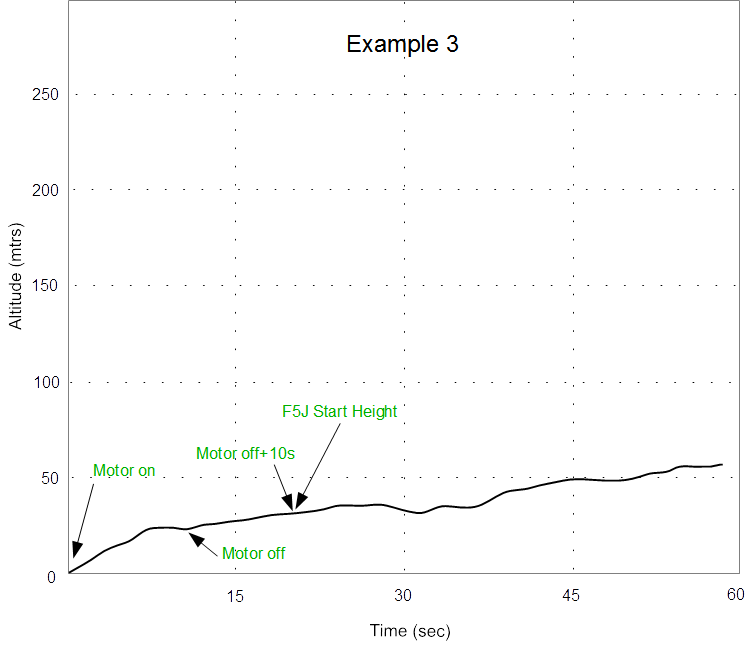
Example 3 shows a typical aggressive fly-off launch where the pilot tries to hook into a low thermal and minimize his Start Height penalty. In this example the motor is cutoff by the pilot at 10 seconds and 25 meters height (Note the plane's launch speed was likely slow to allow the pilot to see low thermal bumps better). Once the motor was cutoff, the pilot immediately started climbing in a low thermal from the motor-off point to the motor-off + 10 seconds. In this specific example, the F5J Start Height is also the height measured at the motor-off + 10 seconds.
For more information on how to setup your altimeter, please see this report: